The MK&P concept might be
similar to one of those “what if” scenarios. What if the Santa Fe had not only beat the Rio Grande to the
Raton Pass, but had also won the contest for the Royal Gorge route?
The layout is arranged in an east to west, right
to left sequence just as it would be if you were looking at a map of this area. It begins in the east on a shelf against the
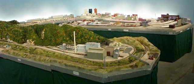
wall and a peninsula depicting an industrialized urban setting occupied by a terminal railroad. In addition to it’s
own trains those of first class railroads, both eastern and western, operate over these tracks. Despite their apparent complexity
the urban tracks in reality are the exposed portion of a simple figure eight loop completed by staging tracks hidden behind
the wall in a workshop.
The MKP mainline diverges from the terminal railroad
and travels west through an interchange with a short-line railroad occupying a second, larger peninsula. This regional receives
unit coal trains it then transfers to a power plant at the end of the line. The tracks of the power plant and the regional's
yard are connected for a “loads-in-empties-out” operation. The other major on line customers of the short-line
are a vegetable oil processing plant and a lead smelter. River bluffs typical of the Mississippi and Missouri river valleys
and a high trestle crossing another river are scenic features of the line. While no attempt would be made to replicate the
prototype, power for this regional would be Arkansas & Missouri Alco locomotives.
Continuing past the interchange, the MKP line enters
the Missouri River town of Jefferson. The town and rail yard rest on a terraced hillside overlooking the river. The largest
customer here is a cement factory located to the west of Jefferson. Other customers include a plastics fabrication company
and a producer of wooden pallets. Jefferson also has a handsome passenger station where Amtrak stops.
Beyond Jefferson trains encounter a junction where
tracks of a north/south route between Kansas City and the Gulf Coast crosses the MKP mainline. (In reality, these tracks connect
the ends of the layout for continuous running.) Beyond the junction the MK&P route traverses Kansas and eastern
Colorado. First stop on the MKP mainline is a Kansas town dominated by a “prairie skyscraper”. Beyond that lies
a town on the Colorado plains with it's principle industry being a sugar beet processing plant. Continuing westbound trains
enter the second major city on the layout. This location would, in some ways, resemble Pueblo, Colorado, with a steel mill
being the dominant customer for the railroad. The plan also anticipates a small refinery, an inter-modal yard, and other,
smaller customers. Amtrak would have a stop at the city's historic station. Upon leaving the Colorado city trains first enter
a deep river gorge before climbing along rugged foothills. Continuing upgrade the tracks finally enter a tunnel which pierces
the Continental Divide.
Upon exiting the tunnel trains pass into a wide
mountain valley surrounded on one side by high buttes and forested peaks on the other. A branch line encountered here makes
a long descent into a deep canyon which bisects this broad valley. The sole customer on the branch is a potash facility.
The mainline keeps to high ground and passes over an imposing bridge which spans the same canyon and the branch line below.
After crossing the bridge westbound trains enter a small town in ranching country. In an earlier era trains might have
stopped here to pick up livestock destined for the feedlots of the Midwest. The railroad now has only a few minor customers
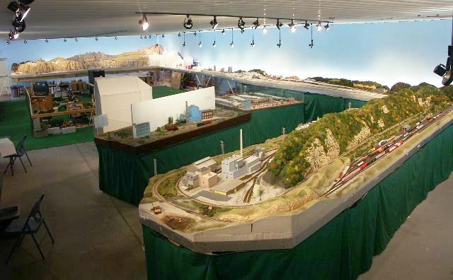
here. Leaving the valley and ranches behind, tracks pass into alpine valleys. Customers are scarce in this area. The railroad
does find an aggregates plant which dredges gravel from the valley floor. A mine and mill tucked against a canyon wall provides
a few loads of lead and other non-precious ores.
An old mining town, it's mines long silent, has
found new life as the location for two important branch lines. One branch hosts unit coal trains going to and from a
mine many miles distant. The second branch is a tourist steam railroad winding among peaks which dominate the mainline below.
Silver mines in this area are long abandoned. Activity today revolves around summer vacationers and tourists. Alta Vista marks
the end of the steepest climb for the steamers and their antique coaches. Tracks disappear into a tunnel before emerging
at the tourists' destination in Nighthawk, another former mining town which clings to the mountainside six feet above the
floor. Even at this elevation the little town is dominated by a peak more than two feet higher. Below the towering peaks the
MKP serves one last customer, a sawmill and treatment plant producing railroad ties and timbers. Amtrak also makes a flag
stop to serve a hot springs spa and hotel. Beyond the hotel, the rails disappear into the narrow Black River canyon and
the end of the visible MKP route.
MK&P Layout Design Goals
This is a freelanced layout but it draws upon prototype
scenes and operations to create realistic and believable models. Freelancing allows more diverse choices of modeling subjects.
While sometimes frowned upon by prototype modelers, this variety is helpful for arousing and maintaining the interest of the
general public this layout is designed to serve. It also speeds up construction by avoiding the detailed research, measuring,
and designing required for true prototype modeling.
A second goal was to
emphasize viewer involvement by 1) bringing track nearer eye level, 2) keeping the viewer close to the trains as often as
possible, and 3) placing the viewer in the midst of scenes. The base track elevation of 48 inches was something of a
compromise. Best viewing for adults would have been higher. However, children were a major portion of visitors to the display.
This elevation is also very comfortable when working on the layout. Separation was maintained between scenes. Aisles were
designed so the layout wrapped around visitors. Thus a visitor was required to move or turn to view another scene .
A further purpose of the layout is to show the historic and contemporary roll and importance of railroads in the
commerce of America. Scenery and structures model scenes from the
contemporary era, however, to inform the public of America's railroad heritage individual trains (historically correct within
themselves) might represent any era or geographic region.
Layout Construction
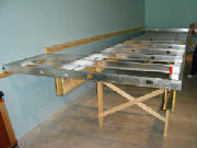
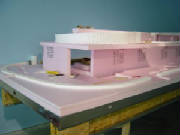
The Missouri Kansas and Pacific layout was built
with innovative techniques and materials. Plywood, which is the traditional building material, is nowhere to be found. Steel
studs now widely used for interior wall construction have been fabricated into supporting grids for sheets of extruded polystyrene
foam insulation. Beams rather than the common 2x2 legs emerged as the best means of supporting the layout. New foam products
(risers and inclines) offered by Woodland Scenics were used to complete the bench work for the layout. The foam construction
necessitated developing new methods for turnouts and other track work. Pieces of foam insulation are used in place of more
traditional wood products along with old-fashioned chicken wire to create the armature and underlying forms to the high mountain
peaks and the Midwestern river bluffs.
Florescent tubes were used as up-lighting for the
sky background to produce a natural blending of sky colors from dark to lighter blue approaching the horizon. While this technique
has been around for awhile it is seldom used. That is unfortunate as a luminous, transparent appearance is given the sky by
this technique. During construction we continued to experiment and look for simpler, more efficient means for completing the
layout and techniques which may advance the hobby.